I'm feeling a little lethargic and unsure of myself at the beginning of this journey but I'll shake off the blues and get started. It is late summer and the plant life along the Pine River is pretty well spent. Sure, the Sugar Maples and Oaks are still green and they continue to reach out to the sun for the sacrament of photosynthesis but there is a seediness to the landscape. Brown leaves flutter along the ground, early casualties of autumn and the beginning of the harvest.
How do you begin at the end? In this case the end is home base. Two Mid-Michigan rivers merge just around the bend from my home on the Rio Pine. The Chippewa Nature Center holds deed to the area and it is easily assessable by way of their 'River Trail'. This picture looks up the Chippewa as the Pine swoops in from the left. This is floodplain. It seems placid and peaceful this time of year but 450 square miles of river basin flows through this fulcrum and the spring floods submerge it with ice jams comprised of puzzle pieces the size of football fields.

The Pine river, just a short hike up from its confluence with the Chipp', runs clear and fast. A metal sign in English and Spanish stands at all bridge crossings this side of the town of St. Louis, Michigan warning that as pure as the glistening waters appear the truth is not so grand. PBB's and DDT can still be found in the mud of the river bottom, toxin's that could build up in warm and cold blooded creatures alike and over time wreak havoc. The sign promises that clean up efforts are under way that will one day make the fish safe to eat again. A catch and release strategy is the proper one for fishermen until that day arrives. It is my understanding that presently there are no funds available and the clean up is stalled .
.
The area surrounding the Pine River has been farmed since it was deforested in the middle 1800's. The 'Green Gold' of Michigan's White Pine forests crashed down these rivers in giant log jams on their way to the saw mills in Saginaw forever changing the ecology of the river. In 1871 huge forest fires swept through millions of acres in the lower peninsula burning up the slashings left by the loggers. Today, these farm lands produce the crops we enjoy at our tables but not without effecting water quality as chemicals essential to modern farming methods escape into our water table. .
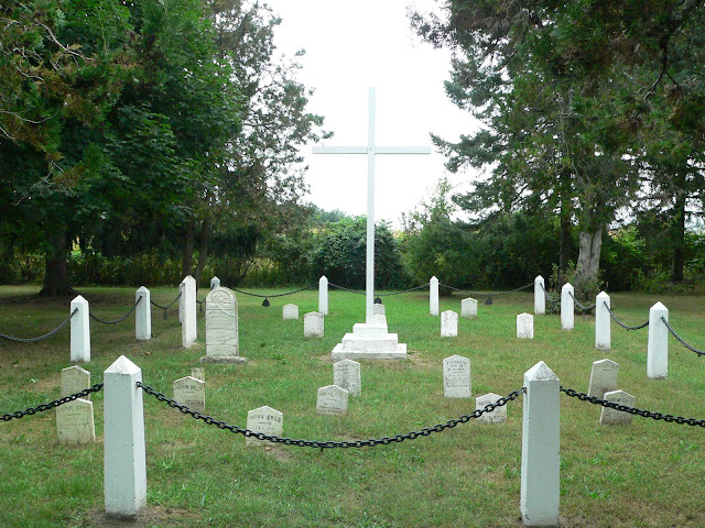
.The Lutheran cemetery for Native American children rests near the Pine not far downstream from St. Louis.
The river is narrowing now as it twists its way through the glacial sediments that established the topography of the Great Lakes region. We are at the outer edge of the Wisconsin Glacier's furthest reach 10,000 years ago known today as the glacial moraine. I close my eyes and imagine looking up at a sheet of ice thousands of feet thick. I shiver.
"Welcome to St. Louis " the sign reads, "Middle of the Mitten." Here the Pine is held in check by this lovely dam. Behind it a large shallow reservoir heats the water before sending it downstream making it inhospitable for the cold water loving Brown Trout that hide further up steam. The chemical plant closed here decades ago though its legacy lives on for todays kids who can't eat the fish they catch or drink the well water.
 or drink the well water.
The Pine river is difficult to appreciate along this lower third as there is little public land adjacent to it. The river bed twists and turns as it flows from the south west toward Midland keeping itself hidden from the road. For the most part, it is a secret place that runs its course quietly and alone.


Lovely post.
ReplyDeleteYou give us a real feel for the river.
Thanks for the very nice input. Enjoyed reading. Awesome photo collection!
ReplyDelete